J2Ski Snow Report - February 13th 2025
J2Ski Snow Report - February 13th 2025
Published : 13-Feb-2025 17:51
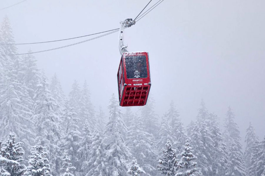
Snow today in many French ski areas, including Megeve...
It's been snowing today in the Alps, although there is milder weather to follow. More heavy snowfalls in Japan, not so much in North America - but it's cold there!
The Snow Headlines - February 13th
- More huge snowfalls take Japan's base depths past 6m/20 feet mark.
- Sunny weather in Scandinavia, which is posting the most terrain open this season so far.
- Most large ski areas in the Alps report nearly all slopes open for half-term holiday crowds.
- The Pyrenees enjoy some of the best conditions of season, with 30cm accumulations.
- Frigid temperatures continue across North America and there's been some snowfalls too.
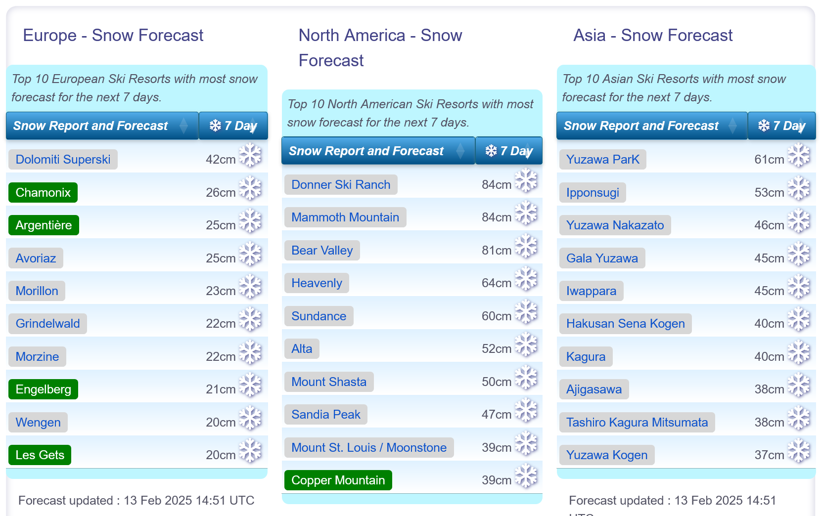
Snow forecasts worldwide.
Re-publication :- the J2Ski Snow Report Summary, being the text above this line, is free to re-publish, but must be clearly credited to www.J2ski.com with text including "J2Ski Snow Report" linked to this page - thank you.
World Overview
The dry weather that has been dominating the weather in the Alps for the past fortnight has begun to break this week with multiple fronts bringing clouds and some mostly light snowfall across the region. Overall, base depths have been dropping as thawing and settling snowpack exceeds the gains. That's not a huge issue though as most resorts remain fully open.
The snow depth numbers and open terrain stats have been on the up in the Pyrenees which has had a second successive week of snowy weather.
Across in North America, it's been another cold week with moderate snowfalls - with heavier ones in the forecast again for the US West Coast.
Japan is topping snow depth and snowfall tables with several centres there now reporting that the snow is lying over 6 metres/20 feet deep, the deepest snow anywhere in the world for several seasons and about double the deepest snow currently reported anywhere else.
Europe
Austria
Austrian ski areas are seeing a little light snowfall after nearly a fortnight of dry weather.
On the groomed runs at least conditions remain good across the country with most resorts fully open, even where snow cover in valleys has melted leaving the familiar white ribbons of maintained pistes descending from above.
It's looking like a snowy end to the week, then back to sunshine for the weekend, and a fresh front bringing more snowfall early next week.
France
The mostly dry weather in France continues after the sunny week last week, although a number of ski areas have had a useful refresh in the last 24 hours.
Southerly ski areas have fared well for fresh falls, with 20-30cm reported by some in the southern French Alps to start the week. It's been heavier in the Pyrenees.
French ski areas continue to post the deepest bases in Europe and conditions are excellent for the busy February half-term holiday period.
The main access road to the Tarentaise Valley (the N90) has been cleared of fallen rocks and is reported to be working well again (albeit with the usual heavy traffic for the half-term weekends).
Almost all slopes are open across the country's larger destination resorts.
After the current snowfall, the weekend currently looks set to be back to sunshine for most areas.
Italy
Italy saw some of the best snowfalls in Europe to start the week and a weather system from the south brought up to a foot of snowfall to the Aosta Valley, Lombardy and Trentino among other areas.
So unusually for this winter, Italian ski centres started the week with more powder than those in the other three big-name ski nations of the Alps!
Madonna di Campiglio was one of the bigger winners, posting 30cm of fresh snowfall. There was also 20cm in the Aosta Valley and some good accumulations for Livigno, Sestriere and others.
Switzerland
The weather has become more changeable on Swiss slopes this week with light to moderate snowfalls reported, initially heaviest in the south and east.
St Moritz and the Engadin posted a 22cm accumulation on Sunday/Monday with the Aletsch Arena reporting a foot (30cm) of snowfall in the same period. For most areas though it was more in the 5-10cm range with cloudier skies than we've seen in recent weeks.
A period of heavier snowfall is now moving in across the country.
Scandinavia
It's been a drier week with plenty of sunshine in Scandinavia.
Ski areas here have been opening additional terrain and are now posting the most they've had open all season, in part thanks to rapidly increasing daylight hours following the dark December-January period.
The deepest snow is on Norway's West Coast where Myrkdalen ski area reports fresh powder and a snow depth approaching 2 metres. Sweden's Are to the east has the most terrain open in the region, about 75km of slopes.
It's looking a little snowier for the week ahead with temperatures continuing to be well below freezing.
Pyrenees
It's been a second good week in the Pyrenees, the region posting some of the best snowfall accumulations in Europe of the past week.
St Lary in France and Formigal in Spain both posted 24-hour 30cm snow totals to start the week. That comes after snowfall the previous week too after a largely dry first few months of the season, so we're definitely seeing the best period of the season to date.
The snowfall is thanks to weather systems moving up from the Med which didn't really reach much further north. Most of the region's ski areas now have the most terrain they've had open all season, typically 70-90% of their runs.
Scotland
Scottish ski areas are still suffering from a shortage of snow following a brief but significant thaw at the start of last week. Otherwise, it's really been a cold month, but as is often the case also a fairly dry one, with very little natural snow build-up.
Glencoe has had the best of it in recent weeks, keeping half a dozen or so natural runs open, with Glenshee doing the same on a more limited basis. Otherwise what's open has been largely restricted to small areas of snow maintained with all-weather snowmaking machines. The Lecht has added terrain park features.
With February half term here centres are warning of limited ticket availability due to the limited terrain. Nevis Range sadly looks set to remain closed and is yet to open this winter.
Eastern Europe
Dry weather has continued to dominate Eastern Europe with plenty of sunshine for the south of the region, more cloud and hill fog between clear spells further north.
Bulgaria has also posted some of the coldest temperatures in Europe over the last week, down as far as -15C and rarely getting up above freezing in the daytime, whilst further north in countries like Czechia and Slovakia it has been more in the -5 to +5C range.
The low temperatures mean there's been little change to snow depths, and have allowed snowmaking to replenish cover lost. Most ski areas in the region, including Bansko and Jasna, remain close to fully open.
North America
Canada
It's been a fairly quiet week for snowfall in Canada, with, if anything, more falling in eastern provinces than western, as happens every now and then.
Low temperatures, down to the -20s (C), continue to be a factor on the slopes.
Most ski areas are reporting good conditions overall, with the low temperatures helping to keep the snow in good shape. Virtually every ski slope in the country is open with good depths in the west and the best conditions of the season to date in the East.
USA
The US has had a pretty good week with some good snowfalls reported in the Rockies, on the West Coast and in the Northeast.
It appears it's set to get even better over the next few days too with major storms approaching on both the Atlantic and Pacific Coasts.
On top of this, it has stayed very cold, which has helped preserve the snow cover and keep most centres fully open. Standouts of the past week include Colorado, which has had a rather dry winter though everywhere is just about fully open, seeing some of its most significant snowfalls to date.
California, where the superstorm last week turned out to be a bit of a washout, until the final few days which delivered several feet of snow, will hopefully see another dump (rather than rain) to end this week.
The Northeast, which has been getting better and better since the start of the year after a poor end to 2024, should also see more cold, snowy conditions.
Join the conversation : Discuss this in the J2Ski Forum
This news item has been viewed 12,859 times.
Also on J2Ski :- Livigno Snow Forecast Ski Hotels Ski Hire Ski Holidays