HochZeiger Ski Resort Guide
HochZeiger, Austria
Rated: 2/5 (from 1 ratings) Write a Review
| Recommended For | Intermediates. |
|---|---|
| Total Piste Length | 54km 34 miles |
| Highest Lift | 2,450m 8,038ft |
| Resort Height | 1,450m 4,757ft |
| Nearest Airports | Innsbruck Airport and St. Gallen-Altenrhein |
| Save on Ski Hire |
HochZeiger
HochZeiger offers a fantastic skiing experience in the Tyrolean Alps. With diverse terrain and stunning views, it’s a perfect destination for winter sports enthusiasts.
Summary
Nestled in the Zillertal Valley, HochZeiger boasts a range of slopes suitable for all skill levels. The resort features 40 km of runs and a welcoming atmosphere that caters to families and adventure seekers alike.
The ski area of HochZeiger is in the Austrian Alps at an altitude of 1,450m 4,757ft , with 54km 34 miles of marked runs.
HochZeiger is part of the Pitztal ski area with access to 48km 30 miles of downhill skiing, with 40 marked pistes, served by a total of 22 ski lifts. In addition to the skiing in HochZeiger itself ( 54km 34 miles of pisted ski runs), the appropriate ski Lift Pass will allow you to ski or snowboard in the other Pitztal ski resorts of Pitztaler Gletscher and Rifflsee.
With ski lifts as high as 2,450m 8,038ft , snow cover is generally reliable.
Notable Ski Runs
The longest possible descent in HochZeiger is 2km 1 miles long.
Partner Offers
Snow and Weather
The snow reliability at HochZeiger is impressive, with average depths of 40-100 cm and consistent snowfall throughout the season. To stay updated on current conditions, check the latest snow info on J2Ski.
When will it snow in HochZeiger?
There is currently no significant snow in the 7-day forecast for HochZeiger.
See our long-range Snow Forecast for the latest update.
Snow this week
| Sa | Su | Mo | Tu | We | Th | Fr |
|---|---|---|---|---|---|---|
Ski Area Stats
HochZeiger Ski Area
| Black Pistes Expert Trails | 4 | |
|---|---|---|
| Red Pistes Intermediate Runs | 7 | |
| Blue Pistes Easy Trails | 2 | |
| Downhill Total Length | 54km 34 miles | |
| Cross Country Total Length | 10km 6 miles | |
| Ski Lifts Number of Lifts | 9 | |
Pitztal Ski Area
| Black Pistes Expert Trails | 6 | 8km 5 miles |
|---|---|---|
| Red Pistes Intermediate Runs | 16 | 29km 18 miles |
| Blue Pistes Easy Trails | 9 | 11km 7 miles |
| Green Pistes Beginner Runs | 1 | |
| Downhill Total Length | 48km 30 miles | |
| Cross Country Total Length | 33km 21 miles | |
| Ski Lifts Number of Lifts | 22 | |
HochZeiger Altitudes
| Highest Lift | 2,450m 8,038ft |
|---|---|
| Lowest Piste | 1,450m 4,757ft |
| Resort Altitude (HochZeiger) | 1,450m 4,757ft |
| Max Vertical | 1,000m 3,281ft |
Ratings & Suitability
| Apres-Ski |
|---|
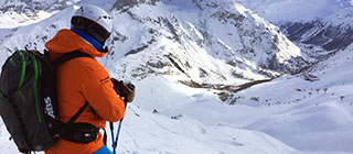
Skiing
HochZeiger's ski area spans the heights of the Zillertal Alps, with elevations reaching up to 2,420 meters. Key lifts include the Hochzeigerbahn and the Zirbenbahn, providing access to notable pistes like the long and winding Piste 3 and the challenging Piste 7.
There is skiing to suit a range of abilities.
Ski Lessons in HochZeiger
To choose a Ski School, and book Group Ski Lessons or a Private Instructor, see HochZeiger Ski Schools and HochZeiger Ski Instructors.
Snowboarding
Snowboarders will appreciate the terrain parks at HochZeiger, particularly the fun park located near the base area. It features jumps, rails, and boxes to cater to all skill levels, ensuring an enjoyable experience.
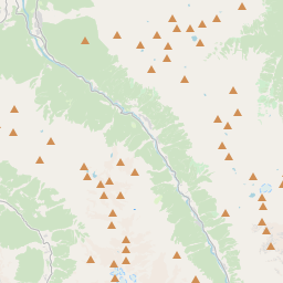
Location and Map
Where is HochZeiger?
This ski resort is in the Austrian Alps.
Map
Tap ![]() for Full-Screen, or see J2Ski's Resort map, showing Hotels and Ski Shops.
for Full-Screen, or see J2Ski's Resort map, showing Hotels and Ski Shops.
How to get there
By Air
The nearest airport to HochZeiger is Innsbruck Airport, 60 minutes drive away.
St. Gallen-Altenrhein, Memmingen, Bolzano, Friedrichshafen and Salzburg airports are all within three hours drive.
Innsbruck Airport is just one hours drive away, in good driving conditions, so you can be on the piste quickly.
Accessing HochZeiger is convenient with major transport routes leading to the resort. The nearest airports are Innsbruck and Munich, both offering straightforward connections to the ski area.
Infrastructure
Ski Lift Capacity
The nine ski lifts are able to uplift 15,400 skiers and snowboarders every hour.
Snow Making
Snow-making is available, on 23km 14 miles of ski runs, with 66 snow cannons.
Season Dates
When is HochZeiger open?
We don't currently have confirmed season dates, but hope to soon.
NOTE:- Ski area, lift and piste opening is subject to Current Snow Conditions.
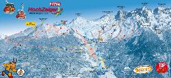
Piste Map
Aprés Ski
After a day on the slopes, unwind at local favorites like the Panorama Restaurant for a warm meal or the Hochzeiger Alm for a cozy drink. For more vibrant nightlife, the nearby bars offer live music and a lively atmosphere.